
Join us as we find and map great boondocking spots, go on hikes, off-road with our Toyota Tacoma and camp in our Fleet Four Wheel Camper. Let's explore and have awesome adventures!
Tuesday, September 15, 2015

Monday, September 14, 2015
San Antonio Hot Springs, New Mexico
 |
| The top pool of San Antonio Hot Springs from Summitpost.org. (Click on it to see it - Google screwed something up.) |
(By Greg) There is a hot springs up in the Jemez Mountains that is pretty cool ... or hot! It is up near a town called "La Cueva" high up in the mountains above Jemez Springs. To access it you must take Hwy 126 past San Antonio Campground (a rare, relatively new Jemez campground with electric / water hookups). You take Forest Road 376 about 5 miles and then you will see a couple old buildings up on the right side and the hot springs are up a slope in that area. GPS Coordinate of the hot springs: (35.939821, -106.643455)
The hot springs is nice as it sits on the steep side of a canyon and has great views and great water. The water pours out of a spout and you can sit under the water spout as it pours out. Apparently, a crew was drilling for access to the geothermal water and hit it big with a huge amount of hot water pouring out. It was too much, or too minerally and they abandoned the spring, and now it is open as a day use area for the public to enjoy. (There may be more to this story, but the bottom line is they created a hole with a large amount of hot water pouring out - thank you very much!)
The top pool is the hottest and then there are about 5 pools on the slope below that folks can enjoy for slightly cooler soaks.
 |
| Looking up to the to pool back in 2005 Joe, Greg and Merrily |
Here are some more photos of the hot springs from our prior visits in 2005 and 2006.

 |
| Karen |
 |
| San Antonio Creek at the base of the hillside hot springs |
 |
| Karen's sister Merrily and our nephews enjoying the natural springs |
 |
| So relaxing! |

The slope up to the pools is a bit sleep, so leave great Gramps at home.
The problem with FR 376 is that it is a 4x4 high clearance road with big nasty ruts in a few places. You can't get a standard car up this road, from my experience. I had a Jeep a few years back that could make it and I took folks up there and we enjoyed the hot spring a ton.
I currently own a Honda CRV all wheel drive. It does pretty good on most dirt roads but it is no Jeep. I don't feel it is the car for getting to the hot springs on FR 376.
I was looking at a map of the area the other day and noticed that FR 144 goes along the canyon ridge right near the hot spring. It struck me that maybe I could drive out there in my CRV, as 144 is a much better dirt forest road then FR 376. I decided to drive with my GPS and figure out if one could get to the hot spring from the west rim of the canyon.
There are a ton of great boondocking spots along FR 144, by the way!
After a lot of hunting around, I found a meadow area on the rim that had a rough trail that led down the steep canyon slope to FR 376, very near to the short trail up to the hot springs from 376.
This trail is extremely steep and you have to side slip down some parts of it, but it is doable by most people in good shape. I wouldn't take Mom, Gramps, or the kids on this trail as it may be too much of a slope for weaker hikers. It's not a long trail. You go down about 350 feet to the bottom.
The climb back up is a real heart pounder. I had to stop quite a few times to let my heart recover from it's massive pounding on the way back up!
The area where this trail / route starts has a few, pretty nice boondocking locations with great canyon views. I plan to boondock up there and hike over to the hot springs at some near future opportunity.
I believe you can get some pretty big RVs back into this area. The road it not too bad. (Don't trust my word, explore it before you try!)
Here is the GPS coordinate of the area to start the hike down from the top of the canyon: 35.946813, -106.644565 . It wasn't hard to spot the little trail down.
There is also a Forest Road just a little further north that leads from FR 144 down to FR 376. It is FR 378. It's not as smooth as FR 144, but I believe I could take my CRV up and down it with no real serious problems. I plan to give it a try soon. [UPDATE: This road FR 376 appears to be closed now.]
If you take this road down, you can drive back south on FR 376 to the base of the hot spring area for the short hike up the slope to the pools. You must open a rickety wire gate at the top of 378 and close it behind you. Cows were standing at the gate when I explored this area. (I guess the grass was greener on the other side? But I kept them from getting through.) There is one big bump to get over right at the top of the road but then it's not all that bad going down. You might have to move a couple of large rocks off the road as you move down it. It's not maintained as well as FR 144.
Here is the GPS coordinate of the top of FR 378: 35.961354, -106.636398 .
There is a surprisingly good little breakfast cafe (maybe lunch and dinner too, but we had breakfast) at the intersection of Hwy 4 and 126. [UPDATE: NOW REPLACE BY A PIZZA PLACE.] It's called Ridgeback. It's next to a small market and in front of the rustic La Cueva Lodge.
Here are some photos from my exploration of this area:
 |
| One of the boondocking sites near the trail down. |
 |
| Looking towards the hot springs area across the canyon. |
 |
| A view looking down into the canyon headed south. |
 |
| A portion of the foot trail down into the canyon. |
 |
| Where I parked near the start of the trail down. |
 |
| A boondocking site next to where I parked at the top of the trail down. |
 |
| More nice boondocking area on the canyon rim. Great views. |
 |
| Looking down into the canyon. |
 |
| Some boondockers along the early part of FR 144 near the main hwy. The got their big RVs in just fine. |
Saturday, September 12, 2015
Monkeying Around - Part I

[By Karen]
For part-timers who work full time - we had an amazing August. We were the ultimate weekend warriors and then some.
 |
| Redondo Campground in Jemez Mountains near Los Alamos New Mexico |
Redondo is a very nice campground with 60 sites, each with picnic table and fire ring. Three of the sites have covered shelters. There are vault toilets, no utility hookups or a dump station. The maximum length is 30 feet. We went up on Saturday and took them out to eat and for a drive.
 |
| For a delicious meal in Jemez Springs, check out the Jemez State Stop |
 |
| In the Jemez Mountains |
 |
| We've had a lot of rain this summer as evidenced by the wildflowers |
 |
| We took Forest Road 376 to the Gilman Tunnels |
The Gilman Tunnels were part of the Santa Fe Northwestern Railway (SFNW) through the canyon which use to transport lumber from the Jemez Mountains. Forest Road 376 has some awesome boondocking, but the area near Gilman Tunnels is NOT suitable for an RV. Read our prior blog about Forest Road 376 here.
 |
| Jemez Mountains |
 |
| Always in awe of this beautiful view from our campsite |
 |
| One of the natural soaking ponds at Valley View |
After the refreshing swim, we drove the 45 minute drive on Hwy 285 to Crestone. Turn at mile marker 105 (Moffat) and head towards the mountains to reach Crestone. The music festival was being held on the Challenger Golf Course. CrestFest operates the music festival and the money they raise goes to bring music to the schools of the rural San Luis Valley. A very worthy cause and great music. This was the 17th year of the festival. We were able to camp adjacent to the venue. They provided toilets, solar showers and water. But, they did not allow pets.
 |
| Our campsite (Humphrey is on the far left) at the Crestone Music Festival |
 |
| Best pizza ever! This is a portable wood stove pizzeria. Hand made from a shipping container and a flatbed truck. Ingenious and delicious |
Last year we attended a music festival/campout that did not include food vendors. We were pleasantly surprised at the variety of food offered in Crestone at the festival. You could even say it was a food fest.
 |
This is a very organized festival. They set up a number of large tent structures for shade and rain shelter. The Great Sand Dune National Park is not far from Crestone. Thus, we should have expected heavy winds. We were enjoying the music, when someone yelled "this tent is collapsing, run!" Not what you want to hear. Everyone scrambled as the tent stakes were pulled up one by one from the heavy wind that was immediately followed by a brief down pour.
 |
| One of several tents set up for shade and shelter from the rain |
 |
| Greg and others hold down the corners of the large tent while one of the organizers re-secures the tent stakes and lines |
 |
| We have had so much rain this summer. The rain leads to an abundance of wildflowers and happy campers. |
 |
| Still happy after all these years! |
 |
| Walking the golf course back toward the music festival grounds |
 |
| Wearing my blanket that was my bridal shower gift (36 years ago) crocheted by a family member |
Chama Train and dinner with John Denver
Stargazing and soak at Valley View
Hiking and soaking in Ouray
Back to the Jemez Mountains and Bandelier for Labor Day hikes.
Saturday, August 1, 2015
Ghost Town Boondocking at Alta Lakes
 |
| I love fields of flowers in the shadow of beautiful mountains |
Because of working full-time, we have to grab time to escape to the mountains whenever we can. I took off last Friday through Sunday and we headed off to Colorado from our home in New Mexico for a little adventure.
We keep our camper van loaded with all the things we need to head out quickly. It usually takes us less than an hour to load up the food, clothes, get ice and gas and be on the road. We left early on Friday morning last week.
 |
| PJ's Gourmet Market, Durango Colorado |
 |
| Million Dollar Highway loopty loop |
It is so relaxing to sit in the main pool late at night and watch the stars. Usually the pool is crowded in the daytime and early evening, but once the day soakers leave at ten, the pools clear out and it is very quiet and peaceful. No electronics (cell phones, cameras, tablets or e-readers) are allowed in the pool area. Friday was the perfect night for soaking due to the cooler temps and misty rain.
 |
| Source: http://www.orvishotsprings.com |
 |
| Sunset at Orvis Hot Springs |
 |
| We went for a walk before soaking, but cut it short when we were attacked by swarms of mosquitoes biting our uncovered legs |
 |
| Jeep with roof tent next to our NV camper |
 |
| James Baroud Offroad Tent |
After soaking, stargazing and a great night's sleep, we were up early to head to our boondocking spot next to a ghost town. But first, we drove the short distance to Ridgway to gas up and have breakfast. We looked up Ridgway's favorite breakfast spot, Kate's Place, and we were not disappointed.
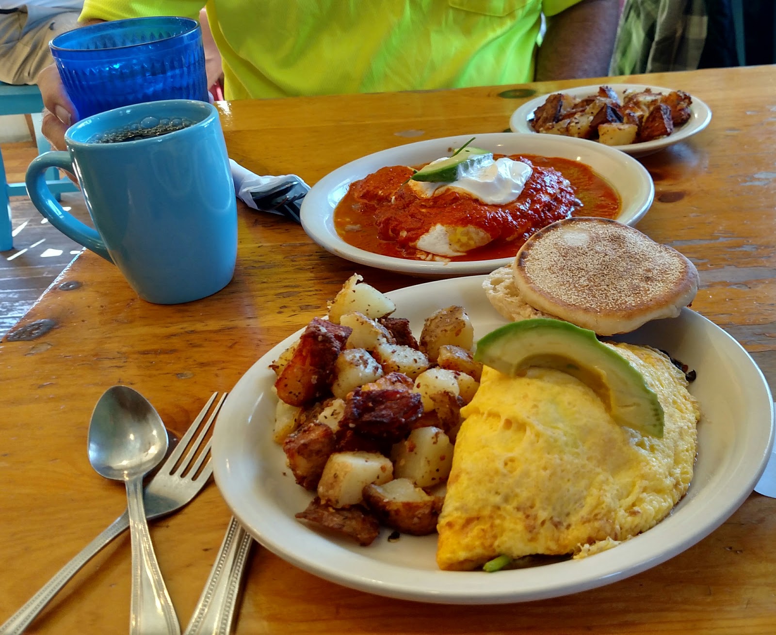 |
| Huevos Rancheros and Veggie Omelet, Kate's Place, Ridgway Colorado |
 |
| Forest Road 623 on our way back down to Highway 145 |
At a narrow part of the road while we were going up hill, we encountered a large truck coming down hill. Greg stopped. The driver of the truck stopped too and then went into reverse. He seemed rather flustered as he flew back up the road way too quickly and much further than necessary for us to pass him. He barely missed hitting a mountain bike racer. Got our hearts racing.
 |
| A wider section of the road to Alta Lakes |
We found an awesome boondocking spot below the ghost town [37.885059, -107.855556]. We got all set up and watched a number of mountain bikes flying down the road. We decided to walk up to the lakes. There was a second pit stop right at the townsite. We stopped and chatted for a few minutes with the woman and her son manning the stop. They told us that this was approx. mile 65 of the 100 mile race. The walk to the lake was very pleasant. We were surprised how many people were camped around the main lake. It was stunningly beautiful. Many people were either fishing or enjoying the lake on their SUPs.
 |
| The largest of the three Alta Lakes |
 |
| We weren't sure if the hammock or the fishing looked more relaxing. |

 |
| The smaller Alta lake with the stunning mountains in the background |
This new spot is inside of a gate that was open. We are not sure if the gate is always open and unlocked, but for the bike race it was this weekend.
After we moved, a man and woman drove up and parked nearby. The woman took off on the trail toward the lakes with her two dogs and the man came by to talk. He asked if we minded if he sat in our camp while he waited for his wife to come back. So, we offered him a chair and the three of us sat in our campsite and talked about boondocking and camping spots. They were staying in a tent trailer up on Lizard Head Pass and live in Taos. They were surprised how packed it was at Lizard Head Pass and agreed with us that we found a perfect spot.


 |
| Mountain view from our campsite. Lizard Head Peak is to the left |

 |
| The perfect, private camping spot. |

We really are enjoying cooking on our Camp Chef gas campfire. We also found the Camco 58033 Little Red Campfire Cook Top works really well to raise up the level of our pan just far enough off the lava rocks but close enough to the heat of the fire. We cook on it and then use it as a quick and easy campfire at night and to warm up on those cold mountain mornings. For boondocking, we also have a small folding table with a cooking extension on it. The perfect dispersed camping kitchen!

 |
| The flowers were in full bloom on our hikes to and from Alta Lakes |
 |
| Can't get enough of fields of wildflowers |
 |
| The ghost mining town of Alta from our camp spot. |

 |
| Reminders of the mining life of Alta |
The Alta ghost town has an interesting history. According to a sign on the large boarding house we were camped near, Alta was a hub of mining activity in the Alta-Gold-King area from 1877 to 1948. Most interesting to us was that Nunn, Tesla and Westinghouse worked at this site with the first industrial use of alternating current electricity. A long distance electric transmission line was completed from the Ames power plant on the San Miguel River below Alta on June 21, 1891. A mill was operated at the Alta site from 1917 to 1948.
The weather on Friday had been overcast and misty. When we woke up Sunday it was to rain. But, Saturday was beautiful and sunny and just perfect for our numerous walks to and around the lake, exploring the ghost mining town of Alta and through the fields of wildflowers. It really was a perfect three-day getaway.
 |
| To give some perspective to the height of the flowers along our hike to Alta Lakes from our campsite, Greg is 6'1" |
 |
| Can't have an adventure without a monkey or two. |
Another good and very large boondocking site is just south of Rico at: 37.639283, -108.058992. It's right on the very pretty Dolores River.
Subscribe to:
Posts (Atom)